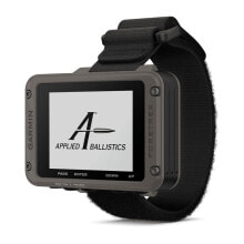
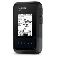
EXPLORE THE OUTDOORS AND STAY CONNECTED WITH HOME
Spend more time on the adventure with this high-quality, rugged GPS and satellite communication handheld device. Enjoy inReach ® technology , which enables two-way messaging, interactive SOS alerts and location sharing 1 , plus maps to keep you on track.
Enjoy more time with up to 165 hours of autonomy in monitoring mode and up to 425 hours in low consumption mode.
Two-way messaging lets you share the moment with the people who matter most.
Let your loved ones follow your adventure with location tracking.
Do you have an emergency? Activate an interactive SOS alert anytime, anywhere in the world.
Track your position in difficult conditions thanks to multi-band technology and expanded GNSS support.
Discover your new favorite places.
MULTI-BAND GNSS SUPPORT
Access various global satellite navigation systems (GPS, Galileo and QZSS). Get access to multiple frequencies sent by navigation satellites to improve position accuracy in areas where GNSS signals reflect, are weak, or normally do not penetrate.
ABC SENSORS
Use the ABC sensors on each tour; They include an altimeter to obtain altitude data, a barometer to monitor weather changes, and a three-axis electronic compass.
SATELLITE IMAGES
Download realistic, high-resolution maps directly to your device via Wi-Fi ® technology . Easily find routes, choose stop and park locations, create waypoints and much more.
PRE-INSTALLED TOPOACTIVE EUROPE MAPS
The pre-installed TopoActives for Europe show peaks, parks, coastlines, rivers, lakes and geographic points.
ADVANCED MAP ELEMENTS
With a subscription to Outdoor Maps+, you´ll get information on public lands, owner names, state land maps, game management unit boundaries, BLM boundaries, and much more.
BATTERY RANGE
Activate low consumption mode and get up to 425 hours of autonomy with inReach technology. In default tracking mode, the battery lasts a maximum of 165 hours, and the device saves your location every 10 minutes.
Stay in touch while on the road.
TWO-WAY MESSAGING
Exchange text messages with loved ones, post on social media, or communicate with another inReach device in the same area.
INTERACTIVE SOS ALERTS
In an emergency, send an interactive SOS message to the Garmin Response SM center , a professional emergency rescue coordination center staffed 24 hours a day.
LOCATION SHARING ABILITY
Track your location and share it with family members back home or with colleagues in the same area. In this way, they can check your progress or request your GPS location, among other actions.
IRIDIUM ® SATELLITE NETWORK WITH TOTAL GLOBAL COVERAGE
Instead of relying on mobile coverage, now your messages, SOS alerts and tracking options are transferred via the Iridium satellite network with global coverage.
GARMIN MESSENGER™ APP
Download the Garmin Messenger app on your compatible smartphone and pair it with your GPSMAP ® 67i handheld device to enjoy fast, easy messaging and 24/7 SOS that aren´t limited to cellular phone coverage areas 1 . The app also supports group messaging.
GARMIN EXPLORE™ APP
Plan, review and sync waypoints, routes and tracks with the Garmin Explore website and app . You´ll even be able to review completed activities in the field.
INREACH OPTIONAL WEATHER FORECAST
Use inReach connectivity to get detailed weather updates to your GPSMAP 67i handheld. Request weather forecasts for your current location, waypoints or route destinations.
ACTIVE TIME
When you connect to the Garmin Explore smartphone app, you´ll get real-time forecasts to keep up with changing conditions.
Find the way for days.
DESIGNED FOR ADVENTURE
This handheld device is designed to meet military standards for thermal performance, shock resistance, and water resistance (MIL-STD-810G), and is even compatible with night vision goggles.
LED FLASHLIGHT
The GPSMAP 67 series helps you avoid having to carry a lot of equipment, since it has a built-in LED flashlight that can be used as a beacon to pinpoint your position in case you need help.
GEOCACHING
Get automatic cache updates from Geocaching Live, with descriptions, logs, and suggestions. When connected via Wi-Fi technology or the Garmin Explore™ smartphone app, each search will be uploaded to your Geocaching.com profile .
Features:
- Screen Size (Width/Height):3.8 x 6.3cm (1.5″W x 2.5″H); 7.6 cm diagonal (3″)
- Battery:Internal rechargeable lithium-ion battery
- Screen Resolution (Width/Height):240 x 400 pixels
- GPS:yes
- Unit Dimensions (Width/Height/Depth):6.2 x 16.3 x 3.5cm (2.5″ x 6.4″ x 1.4″)
- Interface:USB-C
- Water resistance rating:IPX7
- Weight:230g with batteries
- screen type:transflective color TFT
- Battery life:Up to 165 hours with inReach® enabled and 10 minute tracking
- :Up to 180 hours in GPS mode
- :Up to 425 hours in Low Power mode with inReach enabled Up to 425 hours in Low Power mode
- high sensitivity receiver:yes
- Maps and navigation:
- Storage and load capacity:Yes (maximum 32 GB microSD™ card)
- Waypoints:10
- preloaded maps:Yes (Europe TopoActive; with routing function)
- Basemap:yes
- Routes:250, 250 points per route; 50 points of automatic routes
- tracks:20,000 points, 250 saved gpx tracks, 300 saved exercise activities
- memory/history:16 GB (user space varies depending on included maps)
- Ability to add maps:yes
- :
- Characteristics:
- :
- Send route selection to MapShare during route:yes
- QZSS:yes
- BirdsEye:Yes (directly to device)
- Smart switching between Wi-Fi, Cellular and Satellite with Garmin Messenger app:yes
- Send waypoints to MapShare during the route:yes
- inReach weather:yes
- active time :yes
- Contacts:No
- Rinex Registration:No
- inReach Remote Widget:No
- Garmin Connect™ Mobile Compatible:yes
- Touch screen:No
- Beacon LED Flashlight:yes
- InReach®-compatible:No
- astronomical information:yes
- Virtual keyboard to create personalized messages:yes
- Compatible with MapShare with tracking:yes
- IRNSS:yes
- geocaching mode:Yes (live geocaches)
- Sending and receiving text messages to another inReach device:yes
- Automatic routing (turn-by-turn highway) for motor vehicles:No
- Send and receive group messages:yes
- GLONASS:No
- Sending and receiving text messages via SMS and email:yes
- Frequency band:No
- Shows national, regional and local parks, forests and natural sites:yes
- Smart notifications on the handheld device:yes
- Connect IQ™ - downloadable watch faces, data fields, widgets and apps:yes
- Compatible with custom maps:Yes (500 custom map tiles)
- Earthmate-compatible:No
- routes:250, 200 waypoints per way
- dog tracking:No
- wireless connectivity:Yes (Wi-Fi ® , Bluetooth ® , ANT+ ® )
- LiveTrack:yes
- Sharing locations with another inReach device:yes
- Vibration Alert (choose between alert tones and/or vibration alert):No
- map segments:15
- point to point navigation:yes
- Pictures viewer:yes
- barometric altimeter:yes
- SBAS:No
- smart weather forecast:No
- XERO™ Locations:yes
- interactive SOS:yes
- VOX (voice activation):No
- beidou:yes
- ballistics calculator:No
- Automatic route creation (turn-by-turn on highway):yes
- TracBack®:yes
- GPS compass (on the move):yes
- Includes hydrographic features with a high level of detail (coastlines, shorelines of lakes and rivers, swamps and perennial and seasonal streams):yes
- multiband frequency:yes
- Includes POI searches (parks, campgrounds, picturesque watchtowers, and picnic areas):yes
- hunting and fishing calendar:yes
- Activities:yes
- Compass:Yes (3 axis tilt compensated)
- Compatible with Garmin Explore ™ for waypoints, tracks, routes and activities:yes
- tracks:250
- Compatible with Garmin Messenger app:yes
- Galileo:yes
- Compatible with the Garmin Pilot™ app:No
- Compatible with the Garmin Explore website:yes
- area calculation:yes
- MIL-STD-810:Yes (temperature, shock, water); unit only, no accessories
- Location information (sending and receiving GPS positions):No
- Remote Control for VIRB®yes


Мы выстраиваем выгодные партнерские отношения с поставщиками gPS-навигаторов Garmin и отобрали для вас лучших производителей брендовых товаров из Европы, Америки, Турции и ОАЭ, специализируясь на аутлетах и дискаунтерах. Прямая доставка из-за рубежа до покупателя нашими логистическими решениями — это оптимизированные и экономичные решения, вы не переплачиваете в цене товара за расходы на торговые помещения и шоурумы. Заказ будет отправлен напрямую с нашего склада по указанному вами адресу, по цене недоступной для местных магазинов.
Оригинальные брендовые товары в широком ассортименте с вкусными скидками — так можно описать наш интернет магазин. Доставка заказа будет отслеживаться на всех этапах покупки и работает сразу после оплаты заказа.